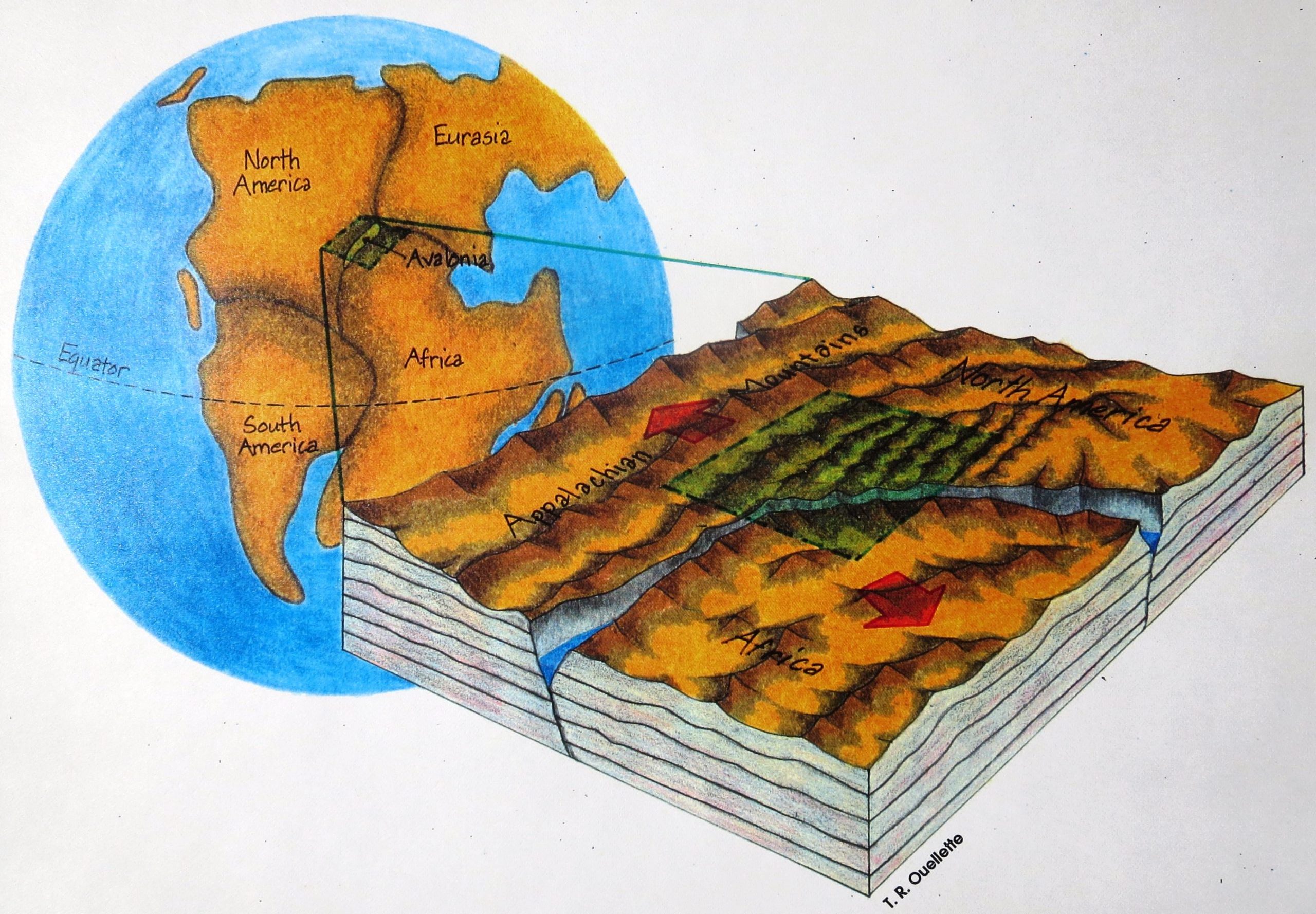
1. ~250,000,000 – ~145,000,000 years ago
By around 250 million years ago plates of continental crust, including the ancient Afro/Eurasian land masses, the Avalonian and Ganderian Archipelagos, and the Americas had converged to form the supercontinent of “Pangaea.” These continental collisions created a long mountain chain that included the Appalachians and stretched across “Pangaea” from south-central North America to south-western Eurasia. Much later (~250-145 million years ago), continental rifting created the Atlantic Ocean. This caused Eurasia and Africa to separate from North and South America. Westernmost segments of Avalonian and Ganderian Archipelagos were left attached to the crumpled edge of North America and eastern portions of the Avalonian Archipelago became “European.” Today, outcrops of the metamorphosed bedrock of westernmost Gander and Avalonia are prevalent along the Connecticut coast between New Haven and the Rhode Island line, and the “European” segments of eastern Avalonia lie along a belt of metamorphic bedrock that stretches from Great Britain to Poland.
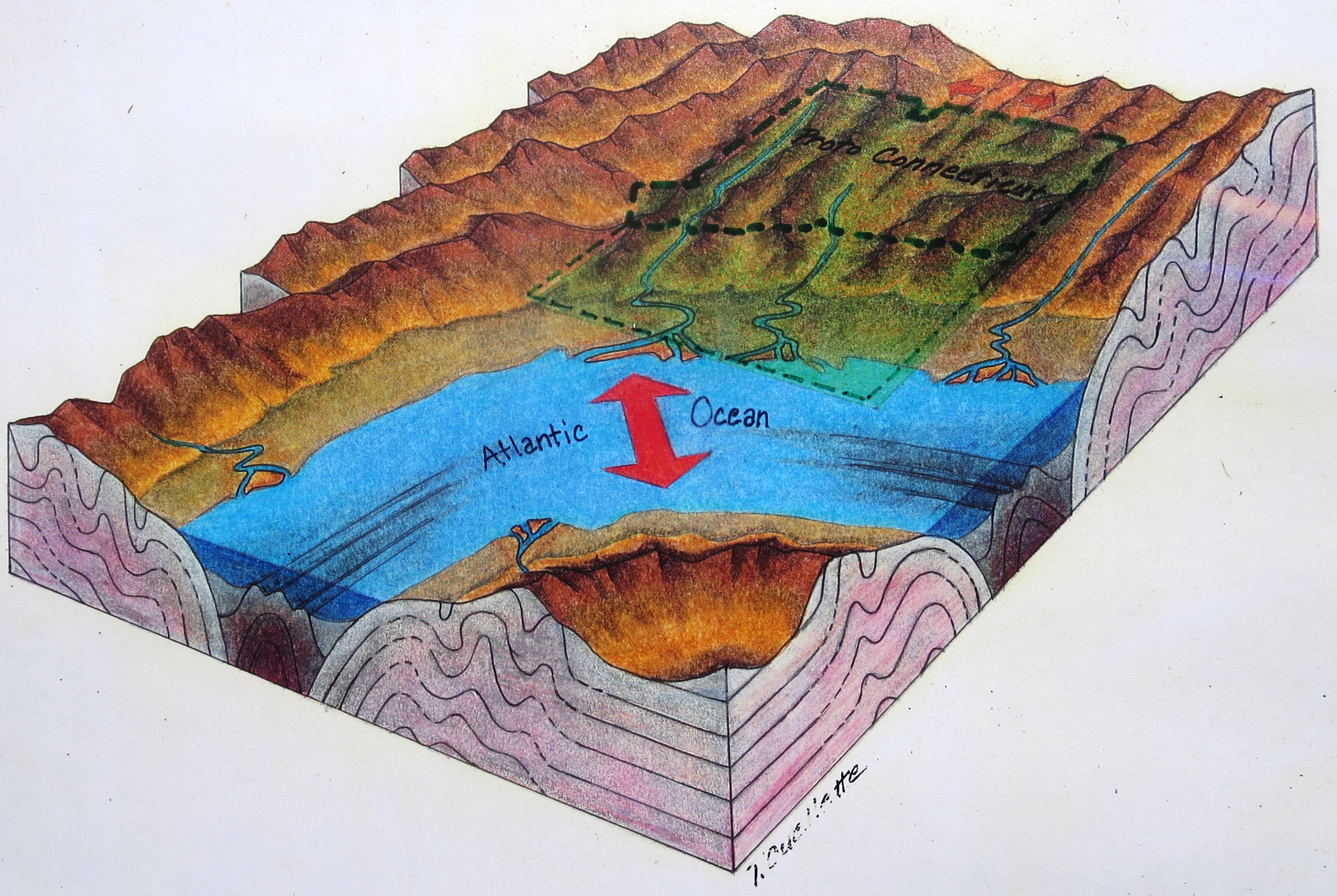
2. ~145,000,000 – ~2,600,000 years ago
During Cretaceous and Tertiary time, sediments derived from the eroding Appalachian Mountain chain were delivered to the expanding Atlantic Ocean basin by east-flowing streams and rivers. Eventually this seaward-thickening sediment wedge became large enough to form the Atlantic Coastal Plain and continental shelf.
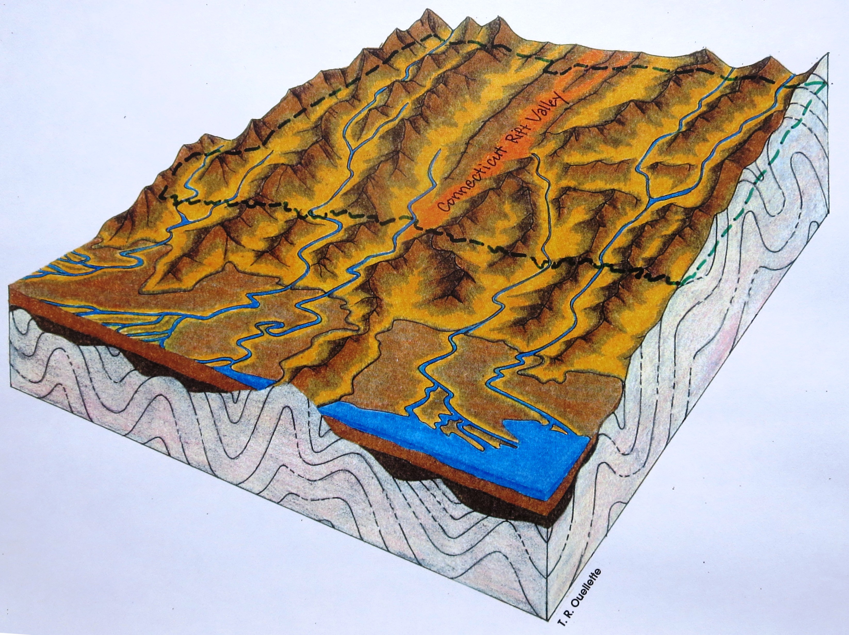
3. ~145,000,000 – ~2,600,000 years ago
In the Long Island Sound area, the same geologic processes were at work. Sediments from weathering and erosion of the Berkshire, Green and White Mountain segments of the Appalachian Chain were delivered to the ocean by streams. As these “Coastal Plain” sediments formed the continental shelf south of Connecticut they became the foundation for what is now Long Island. The dashed line shows where Connecticut would eventually be.
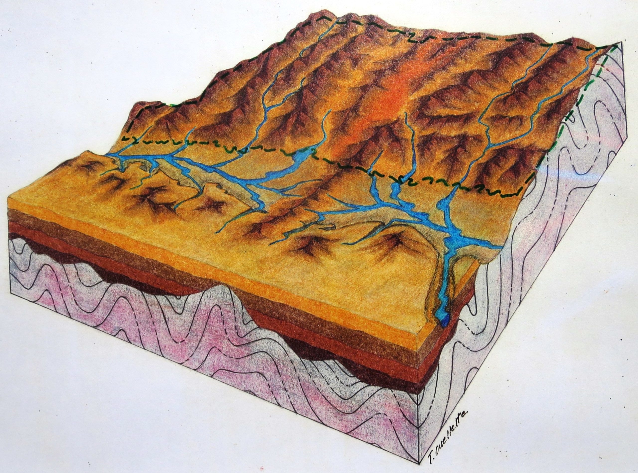
4. ~2,600,000 – ~75,000 years ago
By the end of Tertiary time (~66 million to ~2.6 million years ago), periods of lowered sea level and uplift of the land had promoted active stream erosion which carved into previously deposited “Coastal Plain” sediments and created a stream-cut lowland between Connecticut and the remaining “Coastal Plain” foundation of Long Island. Pleistocene deposits found on Long Island indicate that at least three glaciers advanced across this lowland and reached the Long Island area between 2.6 million and 75,000 years ago. The fourth, and last, glacier to reach Long Island began advancing southward from Canada at the beginning of the Wisconsinan glaciation around 75,000 years ago.
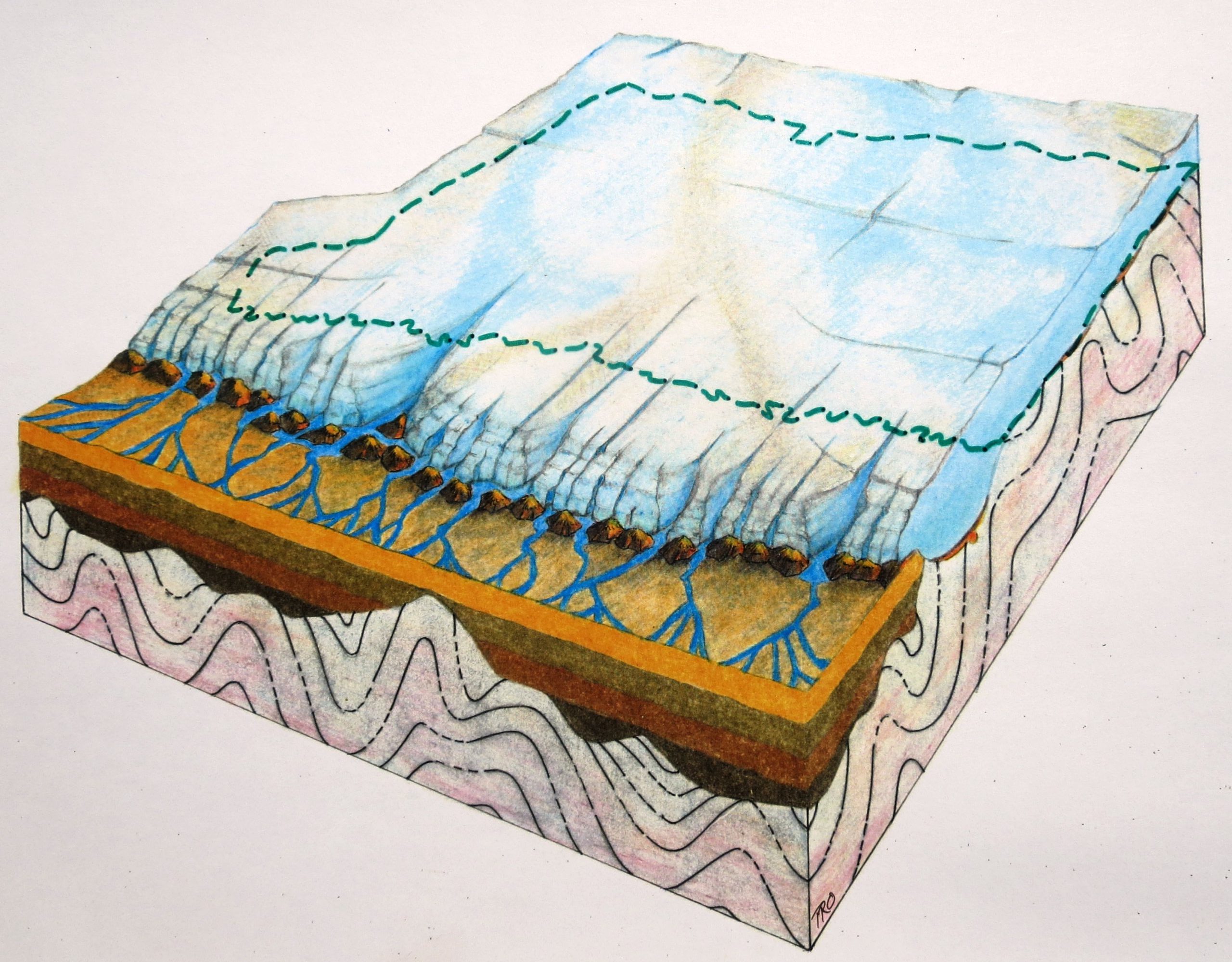
5. ~75,000 – ~25,000 years ago
The Wisconsinan glacier advanced southward to the middle of what is now Long Island by about 25,000 years ago. The moving Wisconsinan ice removed much of the evidence of the earlier glaciations, further smoothed Connecticut’s bedrock, and slightly enlarged the pre-existing “Coastal-Plain” lowland that Long Island Sound now occupies. The line of glacially-deposited hills that characterize Montauk Point and run westward through the middle of Long Island define the position of the Ronkonkoma-Shinnecock-Amagansett terminal moraine. This “terminal position” is as far south as the last ice got. As the glacier was beginning to melt back to its recessional position along northern Long Island, sea level was about 300 feet lower than it is today.
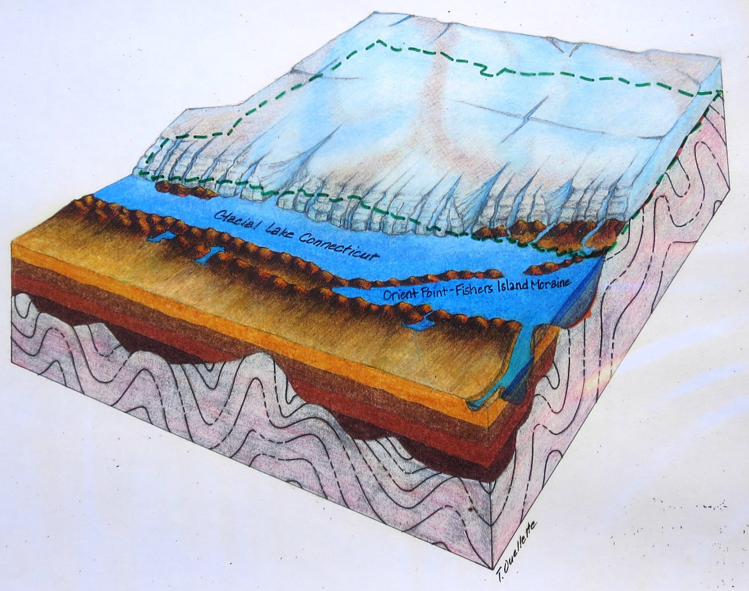
6. ~25,000 – ~20,300 years ago
The recession of the Wisconsinan glacier was occasionally interrupted by pauses in the northward melt-back of the ice front. During these pauses, the ice front lingered long enough to deposit recessional moraines along northern Long Island, in the Long Island Sound Basin, and along the Connecticut shore. The Harbor Hill- Roanoke Point-Orient Point-Plum Island- Fishers Island-Charlestown recessional moraine was deposited during one of those pauses around 21,300 years ago. As melt-back of the ice front resumed, the moraine segment between Orient Point, LI and Napatree Point, RI acted as a dam and the glacial meltwater it impounded began to form Glacial Lake Connecticut. Further melt-back of the glacier, punctuated by minor pauses, allowed Glacial Lake Connecticut to expand and eventually fill the entire Long Island Sound Basin. Glacial Lake Block Island Sound, dammed behind the terminal moraine between Montauk Point and Block Island, also filled the Block Island Sound Basin at this time. As the coast of Connecticut was beginning to emerge from under the melting ice there was another pause, and the Norwalk Island-Lordship-Old Saybrook-Wolf Rocks recessional moraine was deposited around 20,300 years ago. As the melting ice front receded to positions north of Glacial Lake Connecticut, south-flowing meltwater streams carried sediment down emergent ice-free, bedrock valleys and built glacial deltas into the lake. Eastern Connecticut was ice free first, and deglaciation proceeded westward along the coast. As a result, the Glacial Lake Connecticut coastal deltas are progressively younger from Stonington to New Haven. Wave erosion of these glacial deltas is the source for most of the sediment that is currently forming the sandy beaches of the Sound’s north shore.
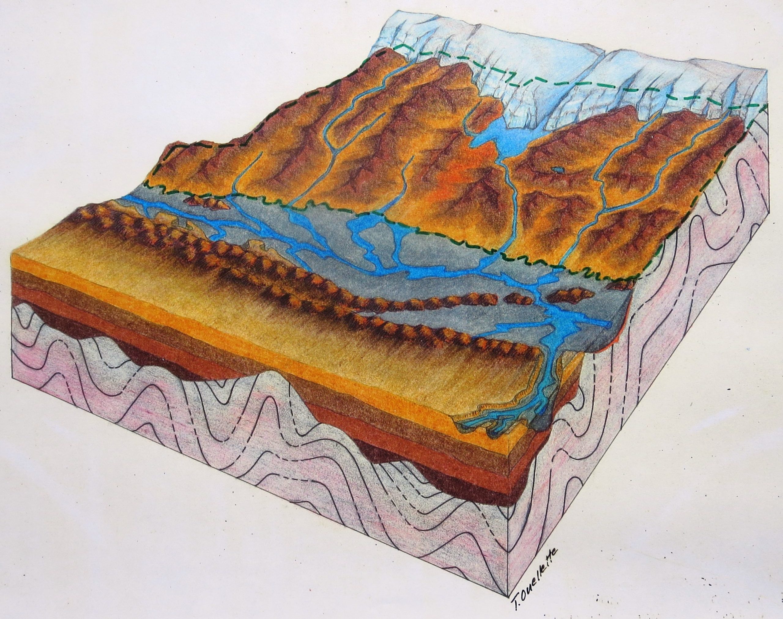
7. ~ 20,300 – ~17,900 years ago
Between about 20,300 and 18,300 years ago, Glacial Lake Block Island Sound was dammed behind the terminal moraine between Montauk Point and Block Island, and, to the northwest, Glacial Lake Connecticut was impounded behind the Orient Point- Napatree Point moraine segment (see Plate 6). Water exiting Glacial Lake Block Island Sound flowed to the still lowered sea through a spillway across the terminal moraine. Since Glacial Lake Connecticut was “upstream” of Glacial Lake Block Island Sound it could not begin to drain down until its “downstream” sister lake had begun draining away. The altitude of deltas is a good indication of the level of the water body they were deposited in. Owing to the way coastal Connecticut was deglaciated (essentially east to west- Plate 6) the oldest and highest Glacial Lake Connecticut deltas are in the east and they get progressively younger and lower westward. This is direct evidence that lake levels in Glacial Lake Connecticut slowly lowered as deglaciation progressed westward along the Connecticut coast. The most likely scenario for this would be slow downward erosion of the morainal spillways for both lakes with Glacial Lake Block Island leading the way. Existing evidence suggests that Glacial Lake Connecticut had completely drained away by around 18,300 years ago and that there was a stream system flowing to the ocean, across the drained lake bed, at that time. By around 17,900 years ago, the melting glacier was almost completely out of Connecticut.
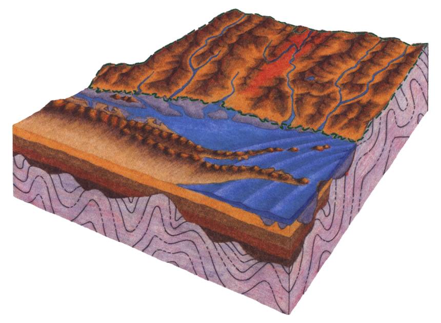
8. ~ 18,300 – ~5,000 years ago
Sometime before about 17,900 years ago, glacial melting had caused sea level to rise sufficiently for ocean waters to begin entering The Long Island Sound Basin. The sea transgressed across the exposed lake bed of the Block Island Sound Basin, through the eroded spillway notch in the Orient Point-Napatree moraine segment, and westward up the stream channels that were cut into bed of the completely drained Glacial Lake Connecticut. This is when Long Island Sound came into existence. The weight of the glacier had depressed the land and it stayed depressed until around 15,300 years ago. By then, the weight of the glacier had been removed long enough for the land to begin to rise (glacial rebound) at a rate faster than global sea level, and sea level in Long Island Sound fell (relative to the rising land). By around 9,000 years ago the rate of rebound had waned and the seal level rise rate in Long Island Sound started to approach the rate of global sea level rise. By around 5,000 years ago, marshes had developed on low-lying, submerged portions of the north shore’s glacial deltas, and the Sound’s coastlines were approaching a configuration that would be familiar to us today. It is important to note that regional tectonic forces (unrelated to glacial rebound) are currently moving the land by about – 0.7mm/year so there is still a bit of difference between relative sea level rise in Long Island Sound and global (eustatic) sea level rise.
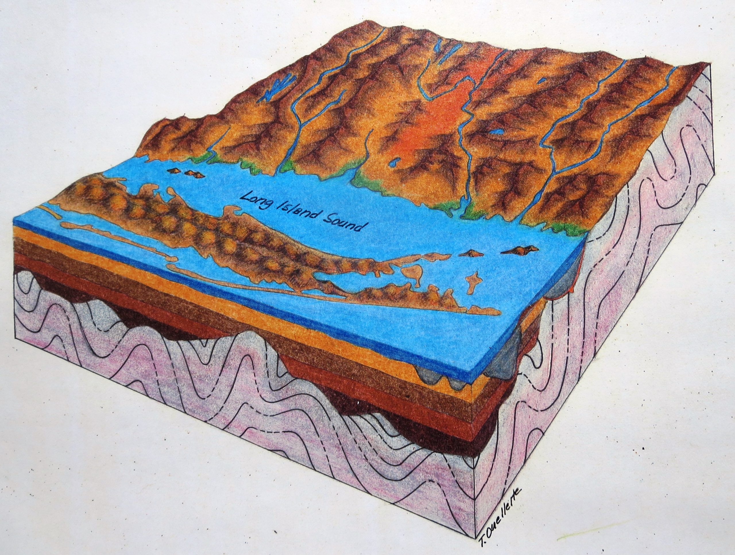
9. ~ 5,000 – Present
Over the past 5,000 years, sea-level rise, and varying degrees of coastal modification by wave action, have worked to shape the Sound’s contrasting north and south shorelines. The amount of coastal modification that waves can accomplish depends on the amount of wave energy available and the vulnerabilities of particular shoreline segments. Unlike places like Misquamicut, RI where large Atlantic waves crash on the exposed beach, Long Island Sound is a relatively protected, low-wave-energy environment thanks the presence of Long Island. In general, the glacially-derived and sediment-rich south shore of the Sound is more susceptible to wave action than its bedrock-dominated and sediment-poor north shore. Along the recessional moraine segment that forms the shoreline between Port Jefferson and Orient Point, wave energy is sufficient to extensively cut into the glacial deposits, creating receding bluffs and a straightening shoreline. In contrast, the Sound’s limited wave energy has done little to alter the irregular, bedrock-controlled configuration of the Sound’s north shore. Its numerous resistant bedrock “points” (that typically flank bedrock valleys, occupied by coves, embayments, beaches and mashes) are being drowned in place (not eroded back) as the coastline migrates landward in the face of the rising sea. The unique north shore of Long Island Sound is the longest stretch of low-energy, rock-dominated shoreline on the U.S. East Coast. Its form and function [e.g.,discrete, isolated sediment sources (glacial deltas) flanked by resistant “points” that interfere with coast-wide long-shore sediment transport and limit robust barrier spit growth; insufficient wave energy and sediment supply for true barrier formation resulting in locally-derived, hybrid pocket/barrier beaches] are quite different from the high-energy, sediment-rich barrier systems, supplied by efficient long-shore transport, that are ubiquitously described in textbooks and in most coastal process-oriented literature. A prudent approach to coastal project planning and design would take these important differences into account.
References
Lewis, R.S. 2014. The Geology of Long Island Sound: Chapter Two in Long Island Sound Prospects for the Urban Sea, Latimer, J.S., Tedesco, M.A., Swanson, R.L., Yarish, C., Stacey, P.E., Garza, C. Eds. Springer Series on Environmental Management, New York, Heidelberg, Dordrecht, London, XXV, 558 p. 182 illus., 112 illus. in color. With 1 4-page color insert.
Lynch, Patrick, J. 2017 A Field Guide to Long Island Sound: New Haven (Connecticut): Yale University Press. 399 p. > 700 illus. ISBN: 978-0-300-22035-3.
Stone, J.R., Schafer, J.P., London, E.H., DiGiacomo-Cohen, M. L., Lewis, R.S. and Thompson, W.B. 2005. Quaternary Geologic Map of Connecticut and Long Island Sound Basin. U.S. Geological Survey, Geological Investigation Series Map I-2784, 68p. 2 map sheets.
Zervas, C., S. Gill, and W. Sweet (2013) Estimating vertical land motion from long-term tide gauge records, Technical report NOS CO-OPS 065, U.S. Department of Commerce, National Oceanic and Atmospheric Administration, Center for Operational Oceanographic Products and Services: Silver Spring, MD, [Available at http://tidesandcurrents.noaa.gov/publications/Technical_Report_NOS_CO-OPS_065.pdf]
- 1/10
- 2/10
- 3/10
- 4/10
- 5/10
- 6/10
- 7/10
- 8/10
- 9/10
- 10/10