Ecosystem Targets and Supporting Indicators
Water Clarity
Improve water clarity by 2035 to support healthy eelgrass communities and attainment of the eelgrass extent target.
View Implementation Actions for Water ClarityProgress
Water Clarity in the open waters of the Sound is used for this ecoystem target because there is currently no systematic tracking of water clarity in embayments and near-shore waters where eelgrass can grow (see Challenges).
| Water Clarity by Avg. Secchi Depth (Meters) | Report Card Grade | |||||
|---|---|---|---|---|---|
| Western Narrows | Eastern Narrows | Western Basin | Central Basin | Eastern Basin | |
| Secchi depth/grade | |||||
| 2008 | 1.57 | F | 2.35 | A | 2.56 | A+ | 2.86 | A+ | 3.24 | A+ |
| 2009 | 1.66 | F | 2.68 | A+ | 2.80 | A+ | 2.95 | A+ | 4.00 | A+ |
| 2010 | 1.67 | F | 2.36 | A- | 2.94 | A+ | 3.16 | A+ | 3.20 | A+ |
| 2011 | 1.29 | F | 2.18 | B | 2.36 | A | 2.51 | A | 3.07 | A+ |
| 2012 | 1.17 | F | 2.16 | B- | 2.47 | A | 2.85 | A+ | 3.02 | A+ |
| 2013 | 1.31 | F | 2.44 | A | 2.51 | A | 2.47 | A | 2.94 | A+ |
| 2014 | 1.33 | F | 2.64 | A- | 3.43 | A+ | 3.38 | A+ | 3.40 | A+ |
| 2015 | 1.36 | F | 2.44 | A- | 2.84 | A+ | 3.27 | A+ | 3.46 | A+ |
| 2016 | 1.19 | F | 2.36 | A- | 2.92 | A+ | 2.86 | A+ | 2.77 | A+ |
| 2017 | 1.17 | F | 2.38 | A | 2.52 | A | 2.80 | A+ | 3.20 | A+ |
| 2018 | 1.24 | F | 2.35 | B | 2.87 | A+ | 3.17 | A+ | 3.14 | A+ |
| 2019 | 1.23 | F | 2.45 | A | 2.77 | A+ | 2.78 | A+ | 3.45 | A+ |
| 2020 | 1.42 | F | 2.25 | B+ | 2.51 | A | 2.70 | A+ | 3.05 | A+ |
| 2021 | 1.47 | F | 2.20 | B | 2.53 | A+ | 2.57 | A+ | 3.41 | A+ |
| 2022 | 1.40 | F | 2.65 | A+ | 3.20 | A+ | 3.45 | A+ | 3.67 | A+ |
| 2023 | 1.20 | F | 2.70 | A+ | 2.90 | A+ | 3.00 | A+ | 3.30 | A+ |
| Water Clarity Grade (numerical and letter grade formats) | |||||
|---|---|---|---|---|---|
| Western Narrows | Eastern Narrows | Western LISound | Central LISound | Eastern LISound | |
| 0-100 scale grade/letter grade | |||||
| 2015 | 35 | F | 92 | A- | 100 | A+ | 100 | A+ | 100 | A+ |
| 2016 | 28 | F | 91 | A- | 100 | A+ | 100 | A+ | 100 | A+ |
| 2017 | 27 | F | 94 | A | 96 | A | 100 | A+ | 100 | A+ |
| 2018 | 30 | F | 87 | B | 99 | A+ | 100 | A+ | 100 | A+ |
| 2019 | 29 | F | 93 | A | 100 | A+ | 100 | A+ | 100 | A+ |
| 2020 | 40 | F | 88 | B+ | 95 | A | 98 | A+ | 100 | A+ |
| 2021 | 43 | F | 85 | B | 100 | A+ | 97 | A+ | 100 | A+ |
| 2022 | 38 | F | 99| A+ | 100 | A+ | 100 | A+ | 100 | A+ |
| 2023 | 28 | F | 100 | A+ | 100 | A+ | 100 | A+ | 100 | A+ |
Status and Trends
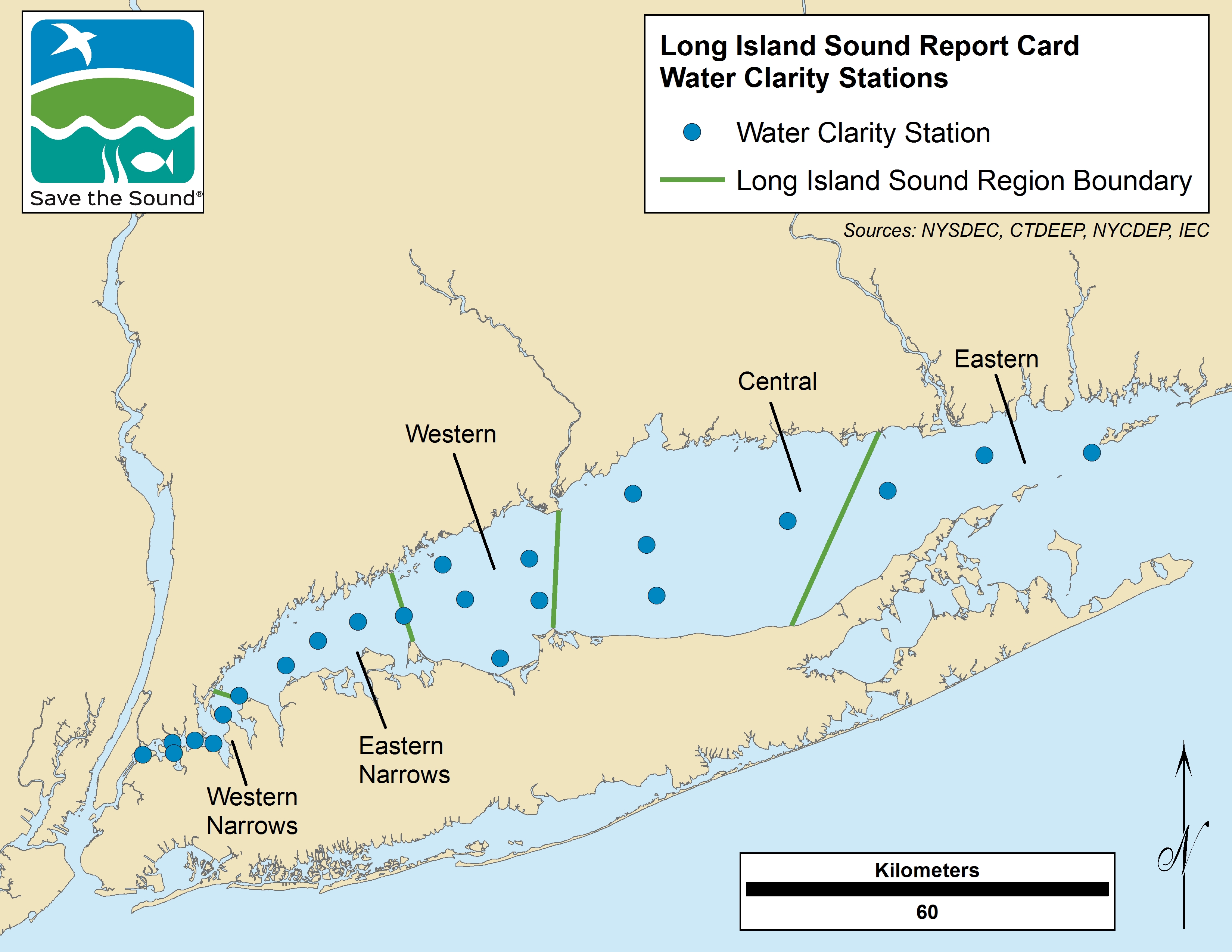
In the open waters of Long Island Sound (where water quality is systematically tracked) there is a general trend of increasing water clarity from west to east in the main stem (open waters) of Long Island Sound. In 2017, for example, average depth of water clarity based on sampling 23 stations, ranged from 1.7 meters (~3.8 feet) in the Western Narrows to 3.2 meters (~10.5 feet) in the Eastern Long Island Sound basin. High report card scores for water clarity by Long Island Sound water basin begin just past the Western Narrows, based on the following water clarity depth thresholds:
- >2.28 m (A- to A+ or 90-100)
- 2.12 to <2.28 (B- to B+ or 80 to 89)
- 1.95 to <2.12 (C- to C+ or 70 to 79)
- 1.8 to <1.95 (D- to D+ or 60 to 69)
- 0 to < 1.8 (F or <60)
The report card scores for water clarity are calculated by Save the Sound as part of its overall health index for Long Island Sound, which is available at https://ecoreportcard.org/report-cards/long-island-sound/health/. From 2015, the baseline year, water clarity has improved in the Eastern Narrows, but remains very poor in the Western Narrows.
Challenges
There is currently no systematic tracking of water clarity where eelgrass can grow in Long Island Sound’s embayments and near-shore waters. The water clarity trends in the main stem of Long Island Sound (see chart above) may not reflect the water clarity of individual embayments where eelgrass is most likely to occur.
Embayment water clarity is measured in some Long Island Sound embayments by the Unified Water Study of Save the Sound, but there is currently no systematic reporting of the information.
Not all the eastern Long Island Sound embayments, which are the most hospitable to eelgrass, are monitored for water clarity.
How is This Target Measured?
Routine monitoring of water clarity is done monthly throughout the year and biweekly in the summer by the Connecticut Department of Energy and Environmental Protection (CT DEEP) and Interstate Environmental Commission.
Water clarity in Long Island Sound is measured using a black and white disc called a Secchi disk, which is lowered into the water until you can’t differentiate the black and white quarters of the disc anymore. This is the Secchi depth, and is an indicator of how clear is the water. Water clarity is measured at approximately 23 stations up to 30 times a year.
Importance
Water clarity is a measure of light penetration into the water of Long Island Sound and is important in nearshore water to allow the growth of eelgrass, which is an important habitat for numerous marine animals.
Eelgrass in Long Island Sound is currently limited to embayments in the far eastern Sound, having disappeared from most of its historic range.
Water clarity can be decreased by high phytoplankton abundance, sediment, or any other types of suspended particles in the water.
Additional Information
- 2012 Distribution of Eelgrass
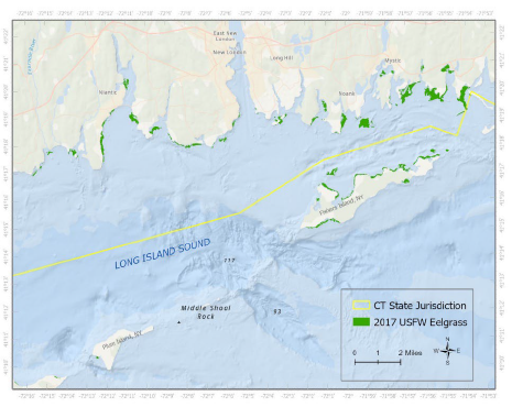
This figure (Source: Bradley and Paton, 2018) shows the 2017 distribution of eelgrass in eastern Long Island Sound in 2017, as determined by aerial surveys conducted by the US Fish and Wildlife Service (in green). In this area of eastern Long Island Sound eelgrass covers about 1,465 acres of the seabed along the Connecticut coast; Fishers Island, New York; and very limited parts of the shoreline of the North Fork of Long Island. These 1,465 acres represents almost all the known eelgrass in Long Island Sound.
2. Potential with Adequate Water Clarity

Dr. Jamie Vaudrey and colleagues* developed a model showing the maximum potential area of the bottom of Long Island Sound which could be colonized by eelgrass based on water depth, mean tidal amplitude, and percent of surface light reaching the bottom (the Exclusive Band). This assumes all other characteristics of the environment, such as water quality, are optimal, and the area would be reduced by sea level rise. Currently only 1.28% (8.34 km2 of 651.8 km2) of this potential area is colonized by eelgrass.
*Vaudrey, J.M.P., J. Eddings, C. Pickerell, L. Brousseau., and C. Yarish. 2013. Development and application of a GIS-based Long Island Sound Eelgrass Habitat Suitability Index Model: Final report submitted to the New England Interstate Water Pollution Control Commission and the Long Island Sound Study.
Contacts
Katie O‘Brien-Clayton, CT DEEP
Katie.OBrien-Clayton@ct.gov
Evelyn Powers, IEC
epowers@iec-nynjct.org
Peter Linderoth, Save the Sound
plinderoth@savethesound.org
Dr. Jamie Vaudrey, UConn
jamie.vaudrey@uconn.edu
Source of Data
Water clarity data for the main stem of Long Island Sound from the Connecticut Department of Energy and Environmental Protection (primary data source), and the Interstate Environmental Commission (IEC) for Western Long Island Sound. Additional data for embayments will be sourced in the future through Save the Sound and Dr. Vaudrey.
DATA NOTES
- The technical explanation on how the target was selected is found in Appendix B of the Comprehensive Conservation and Management Plan.
- Long Island Sound Report Card grading takes station area and time weighting into account in determining the final regional grade.