Ecosystem Targets and Supporting Indicators
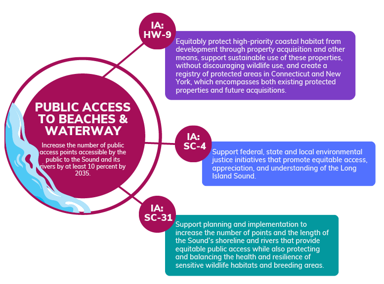
Public Access to Beaches and Waterways
Increase the number of public access points accessible by the public to the Sound and its rivers by at least 10 percent by 2035.
View Implementation Actions for Public Access to Beaches and WaterwaysProgress
| Public Access Sites | ||||
|---|---|---|---|---|
| Year | CT sites | NY sites | Total (CT + NY sites) | Net New Sites |
| 2014 | 328 | 176 | 504 | 0 |
| 2015 | 328 | 176 | 504 | 0 |
| 2016 | 329 | 176 | 505 | 1 |
| 2017 | 330 | 177 | 507 | 2 |
| 2018 | 340 | 177 | 517 | 10 |
| 2019 | 341 | 177 | 518 | 1 |
| 2020 | 346 | 177 | 523 | 5 |
| 2021 | 346 | 177 | 523 | 0 |
| 2022 | 358 | 177 | 535 | 12 |
| 2023 | 363 | 177 | 540 | 5 |
| 2024 | 368 | 177 | 545 | 5 |
Status and Trends
To meet this target, the number of public access points accessible by the public would need to increase by 50 sites by 2035 (more than two sites per year). Since 2014, Long Island Sound has gained forty public access sites. Therefore, as of 2024 the Long Island Sound Study is 80 percent towards the goal.
Challenges
Providing additional coastal access contends with many challenges. One of the most difficult of which is the development along the coast. The coast of Long Island Sound is highly developed and largely private property. In fact, in Connecticut 61 percent of the entire population resides along the coast and 81 percent in New York. Additionally, municipalities contend with the complexities of balancing revenue from additional development, maintaining a quiet neighborhood/community feel for its residents, preserving lands, providing public access, and ensuring the resources are available to maintain those preserved and public properties.
Furthermore, as can be noted in the Sea Level Rise and Storm Surge Viewer (CIRCA) many of our coastal access areas are directly in the path most at risk for sea level rise. This will pose additional challenges yet to be fully addressed.
How is This Target Measured?
The Long Island Sound Study considers any site that is open to the public for boating, swimming, fishing, hiking, or any other outdoor activity along the Long Island Sound and its rivers shoreline as a public access site.
Connecticut’s Department of Energy and Environmental Protection (CT DEEP) maintains a Coastal Access Guide designed to help the public explore and enjoy the Connecticut shore. Connecticut’s interactive guide provides information about each individual coastal access site along Connecticut’s shoreline. The total number of sites and new sites added each year are extracted from the Coastal Access Guide to provide the data for this metric.
New York State distributed a public access survey to New York municipalities in the Long Island Sound watershed. The responses to the survey were analyzed and a list of public access sites for New York was generated, this provided a baseline of 176 sites for New York’s Long Island Sound area. An updated survey is being conducted to evaluate the current status of public access sites and this site will be update upon completion of the updated survey.
How is this Target Addressed?
Each Ecosystem Target is supported through the tangible strategies known as Implementation Actions (IA) that are identified in the Long Island Sound’s 2020 Update to the Comprehensive Conservation and Management Plan (CCMP).
In the 2020-2024 CCMP update, the primary implementation action identified to address this particular ecosystem target is “Support planning and implementation to increase the number of points and the length of the Sound’s shoreline and rivers that provide equitable public access while also protecting and balancing the health and resilience of sensitive wildlife habitats and breeding areas.” This implementation action is currently being address through two on-going projects: “Coastal resiliency assessment: near-term coastal change along the shorelines of Long Island Sound” led by the USGS” and a multi-phased program led by the Connecticut and New York Seagrants, “Long Island Sound Connecticut Public Outreach Program”. To see more about projects addressing Long Island Sound CCMP see the Program Implementation and Progress page. The other implementation actions which address this ecosystem target are illustrated in the figure below.
Importance
Public access to the shore for all is an important principle for Long Island Sound Study’s Comprehensive Conservation and Management Plan.
The Long Island Sound has over 580 miles of coastline. This coastline provides home and a multitude of resources to an estimated 20 million residents within 50 miles of the shoreline (see the Indicator, Population Within 50-mile Buffer of Long Island Sound, for more information).
Public access to the Long Island Sound shoreline provides resources that benefit the economy and health of the residents and visitors of the Sound. Specifically, in New York, marine resources (including Long Island Sound) provide 16.1 billion dollars in wages, and in Connecticut (which is entirely based on the Long Island Sound) provide 2.1 billion dollars (see the 2022 Marine Economy Report by NOAA for further information). Additionally, the Long Island Sound is a significant source of food where each year, in Connecticut, approximately 10,000 citizens procure permits to harvest shellfish (source: Catching Value, 2021). In New York, over 430,000 marine licenses were issued between 2019-2020 (source: NOAA, Office of Coastal Management).
Furthermore, the value of natural spaces for recreation is only beginning to be understood. Studies have shown that exposure to parks can improve physical and mental health and can provide cost effective health care opportunities. (Source: 2022, Larson et al). The value that the public spaces of Long Island Sound may provide maybe immeasurable.
Contact
Samarra Scantlebury, NYSDEC
samarra.scantlebury@dec.ny.gov
Adelaine McCloe, CT DEEP
adelaine.mccloe@ct.gov
Kathleen Knight, CT DEEP
kathleen.knight@ct.gov
Source of Data
CT DEEP, NYSDEC (see Data Notes)
DATA NOTES
- The technical explanation on how the target was selected is found in Appendix B of the Comprehensive Conservation and Management Plan.
- Connecticut data is compiled from CT DEEP’s Coastal Access Guide. New York data is being derived from a public access survey and data from NOAA’s Marine Recreational Information Program site registry.
- *Until the New York Survey is updated the NY data is presumed to be static from 2107 on.
- https://coast.noaa.gov/states/connecticut.html
- https://coast.noaa.gov/states/new-york.html
- https://circa.uconn.edu/sea-level-rise-and-storm-surge-viewer/
- Nature-based Pathways to Health Promotion: The Value of Parks and Greenspace Lincoln R. Larson and J. Aaron Hipp. North Carolina Medical Journal March 2022, 83 (2) 99-102; DOI: https://doi.org/10.18043/ncm.83.2.99
- Connecticut’s Long Island Sound Blue Plan
- Long Island Sound Blue Plan Viewer