Ecosystem Targets and Supporting Indicators
Riparian Buffer Extent
Increase the percent area of natural vegetation within 300 feet of any stream or lake in the Connecticut and New York portions of the Long Island Sound watershed to 75% (1,030 square miles of natural vegetation) by 2035 from 2010 baseline of 65%.
View Implementation Actions for Riparian Buffer Extent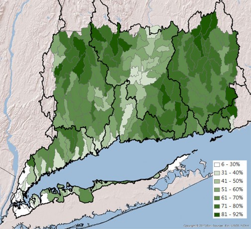
Progress
| Total Area of Vegetation Along 300-foot Riparian Corridor (sq miles) | |||||
|---|---|---|---|---|---|
| NY (vegetated) | CT (vegetated) | Total NY/CT (vegetated) | Total NY/CT (vegetated&developed) | % NY/CT (vegetated) | |
| 1985 | 30.47 | 895.57 | 926.04 | 1374.02 | 67.40 |
| 1990 | 30.20 | 881.07 | 911.27 | 1374.02 | 66.32 |
| 1995 | 29.75 | 870.19 | 899.94 | 1374.02 | 65.50 |
| 2002 | 29.51 | 863.64 | 893.16 | 1374.02 | 65.00 |
| 2006 | 29.46 | 860.45 | 889.91 | 1374.02 | 64.77 |
| 2010 | 29.31 | 858.59 | 887.90 | 1374.02 | 64.62 |
| 2015 | 29.28 | 860.59 | 889.86 | 1374.02 | 64.76 |
| Percent to Goal to Increase Vegetated Buffer by 10% | ||||
|---|---|---|---|---|
| Year | Total Vegetated Area (sq. mi.) | Change from Baseline (sq. mi.) | % Vegetated (rounded to nearest whole number) | Percent to Goal |
| 2010 | 887.90 | - | 65% | - |
| 2015 | 889.86 | +1.96 | 65% | 0% |
Status and Trends
Meeting this target requires an average increase of vegetated riparian buffers of 0.4% per year from 2010-2035. A 25-year dataset up to the baseline year of 2010 indicates that vegetated buffers in riparian zones are declining. In 2010, 64.71 percent (rounded to 65 percent in the goal) or 889.83 square miles were vegetated compared to 67.64 percent in 1985.
There are 1,315.1 square miles in Connecticut and 60.1 square miles in New York within 300-foot riparian corridors in the Long Island Sound watershed.
Challenges
Limit development and/or build development with green infrastructure around the shorelines of all water bodies in order to provide a buffer that effectively removes groundwater before it enters into receiving waters.
How is This Target Measured?
University of Connecticut Center for Land Use Education and Research (CLEAR) has tracked riparian buffers within 300-feet of streams and waterways about every five years in the Long Island Sound watershed using satellite imagery (See Data Note).
Importance
Riparian zones, a corridor or strip of land of a specified width along streams and waterways, with native vegetation and soils are the first line of defense against the impacts of impervious surfaces such as streets and parking lots.
Natural riparian areas slow runoff, protect shorelines from erosion, aid in flood control, and filter or trap pollutants. They also provide habitat and corridors for wildlife, as well as shade waters for fisheries enhancement. Additionally, intact riparian corridors may provide scenic value and recreational opportunities.
The natural or vegetated portion of riparian corridors is sometimes referred to as riparian buffers.
Additional Information
There are very few sub-watersheds in Long Island Sound with sufficient riparian buffers to assure “pristine” water quality of streams and rivers.
The higher the percentage of naturally vegetated land in this buffer zone is, the healthier the stream or river will be. A rough rule of thumb is that a river with >90 percent of the buffer zone vegetated is considered “pristine”, while a river with <75 percent vegetated buffer is considered “impacted.” The above map showing the health of riparian buffers by subbasin reveals that there are few subbasins with the vegetated cover necessary to be considered pristine.
Contact
Robert Burg, New England Interstate Water Pollution Control Commission
rburg@longislandsoundstudy.net
Source of Data
UConn Center for Land Use Education and Research
DATA NOTES
- The technical explanation on how the target was selected is found in Appendix B of the Comprehensive Conservation and Management Plan.
- The methodology used to map the riparian zones is described at the UConn CLEAR website.
- CLEAR Story Map on CT Changing Landscape
- CLEAR’s Connecticut’s Changing Landscape study
- One-foot resolution data from 2012 for impervious cover was mapped for Connecticut (UConn)