Systemwide Eutrophication Modeling

The Long Island Sound Study (LISS) and its partners have taken the initiative to develop a new generation of models to better describe dissolved oxygen concentrations as well as address new challenges such as warming temperatures, increasing precipitation and more development that can threaten the progress that has been made. The newly updated model will allow researchers to forecast how the Sound may respond to changes in human (e.g., pollution) and natural (e.g., weather) drivers that impact the system. The model will also enable managers to evaluate potential impacts of point source discharges, nonpoint source discharges, and sediment fluxes on water quality.
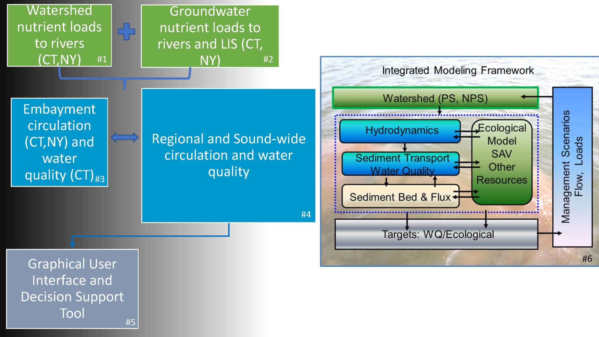
In 2019, the New York City Department of Environmental Protection (NYCDEP), with support from LISS, released a Request for Proposals (RFP) for the development of a new regional integrated model framework (Diagram 1, #6) for the region’s waters. These waters include Long Island Sound, New York Harbor, and New York-New Jersey Bight (the waters along the Atlantic coast extending from Cape May in New Jersey to Montauk Point on the eastern tip of Long Island). This initial effort will include hydrodynamic, water quality, and ecological sub-models (Diagram 1, #4) as well as a graphical user interface and decision support tool (Diagram 1, #5). It will build and improve upon the previous generation of models to guide future planning and management based on the best currently available science. This RFP was developed following the production of a detailed report by a technical advisory committee composed of local and outside modeling experts. Work is expected to begin in summer 2020 and continue to 2024. Future projects to add ecological and related models are planned.
Under an agreement with EPA, NYCDEP is designing a model that integrates physical, biogeochemical, and ecological sub-models to represent these components in Long Island Sound:
- Water Circulation
- Water Mixing
- Sediment Flux of Nutrients (also known as Internal Loading)
- Dissolved Oxygen Levels
- Water Quality
- Ecological Conditions Affecting Seagrass, Tidal Marshes, & Fish
In 2020, NYCDEP entered into contract with HDR to conduct the modeling.
Outcome: This multi-year project will strengthen management of Long Island Sound and guide investments in pollution control for the next decade by NYCDEP, NYSDEC, Connecticut Department of Energy and Environmental Protection (CT DEEP), New Jersey Department of Environmental Protection (NJDEP), and EPA. The modeling project will also support compliance with regulatory goals (municipal stormwater, combined sewer overflows controls, TMDLs) at multiple scales:
- system-wide (New York Bight, New York Harbor and Long Island Sound)
- regional (Long Island Sound and New York Harbor)
- local (embayments, tidal rivers)
Once complete, EPA and NYCDEP’s goal is to provide access to model results to all stakeholders including the academic community, state agencies, federal agencies, local agencies, environmental organizations, and regulated entities.
Expected Availability Date: 2025
Contact: Greg Wilkerson, gwilkerson@dep.nyc.gov, NYCDEP